

Richard Lutz decides it’s time to re-consider 216, 191 and good old number 50.

Not long ago, as spring began to warm your skin, Phil and I found ourselves stuck in a corner of a Warwickshire field. There should have been a path through a hedge – maybe a stile or a gate or even a trace of a little mud track.
But it was a solid ten dollar hedge. It was impassable. “Look at the OS,” I was told. After all, the Ordnance Survey maps for Britain are never wrong.
But it was. The path was on the other side of a busy arterial road between Stratford and Coventry. Traffic roared past.
The OS map was wrong. It couldn’t be. But it was. OS maps are never wrong. Youe eyes may disbelieve, your brain cry “No!!!”. But the final say was where an OS map told you to go. Except in this case, of course.
I have been using these maps for decades. And, honestly, they are bang on. And this little escapade with the path that wasn’t there was the first time the OS cartographers got it wrong. First time in decades that I’ve been using them.
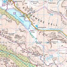
OS maps, from the top of Cornwall to the Shetlands, are the topographical portrait of Britain. Where else can you find Wyre Piddle except on the OS map for deepest Worcestershire? Where else can you find Leathach Mountain except on the one for Torridon in the empty northwest of Scotland where the hills meet the sea? Where else, time after time, can you find the old village pub that sits right next to the symbol for a public phone or a disused church?
And now comes the rub: I’m chucking a whole lot. Out goes the 1:50,000 Map number 50 for Glen Orchy in central Scotland. Out goes map 15 for South Dorset which gets you to East Stoke Fen Nature Reserve and just south to what must be one of a billion Manor Farms dotting this isle of little places.
Is it a heresy to chuck them? Compost them? Give them away, push them over a charity shop counter? After all, each, now smattered and smudged with mud and rain and going to pieces where they have been folded and re-folded and crunched in a backpack, has been bought for a reason – and used. Each one has a story, a tale, a wrong turn, a little adventure. Each has that OS visual grammar that is pounded into your head.
But there are too many and, let’s face it, those mobile maps and walking apps are pretty good.
But there is something about having all four of the 1:25,000 big time Outdoor Leisure maps for The Lakes (numbers 4 to 7) or the heavily contoured number 8 for the Cuillen Mountains on Skye or, Gtod bless it, number 191 which takes in the quiet and calm of the north Cotswolds, where you can turn a corner from a tourist village and not see anyone for ten miles as the map takes you up sweeping hills speckled with tiny villages.
But they’re going; tattered, ragged, packed full of places with names like Nineveh, Fodge Farm and, for some reason, Hydrauilc Ram which sits between minuscule William’s Copse, Northdown Barn and a whole bunch of hilly, tight contours that would wear you out in no time when you have to climb up an unending edge.
The man at the charity shop (you’re never five minutes from a city charity shop) is grateful for the bag of maps. “People still like them,” he said as he piled them up and took sudden notice of 206 which takes in Edge Hill and Fenny Compton in South Warwickshire and includes six major long distance walking routes. “There’s nothing like a map.
“After all, a wood doesn’t change, a road doesn’t disappear, an old church doesn’t up and move.” Then he took the maps but laid 206 carefully aside. It’s a good map, that.